Destinations:
- Bath
- Belgium
- Bradgate and Groby
- Corfe Castle
- Dorset
- Dorset's Beaches
- The Grand Canyon
- Greece
- Hawaii
- Hawaii's Volcanoes
- The Hoover Dam
- Ibiza
- Ireland
- Kenilworth
- Las Vegas - 1
- Las Vegas - 2
- Montreal
- New York
- Niagara Falls
- Salisbury
- Scotland
- Skellig Islands
- Special Effects and Others
- Stonehenge
- Stratford
- Toronto
- Warwick
- York
890,000 visitors
since March 2001.

Toronto
Canada |

|
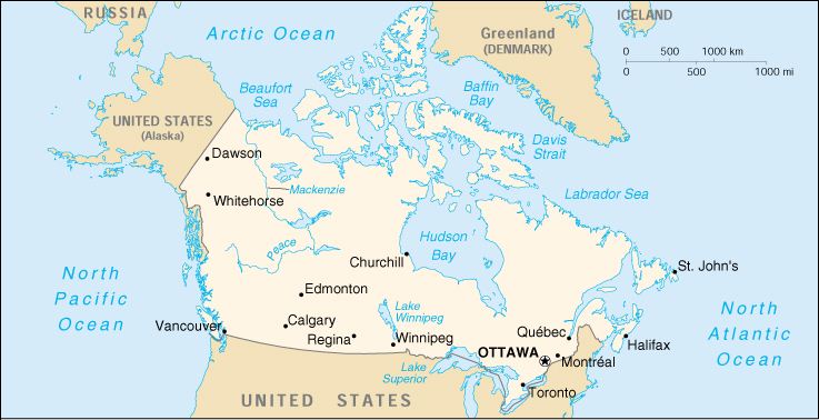
Background: A land of vast distances and rich natural resources, Canada
became a self-governing dominion in 1867 while retaining ties to the British
crown. Economically and technologically the nation has developed in parallel
with the US, its neighbor to the south across an unfortified border. Its
paramount political problem continues to be the relationship of the province
of Quebec, with its French-speaking residents and unique culture, to the
remainder of the country. Location: Northern North America, bordering the North Atlantic Ocean and North Pacific Ocean, north of the conterminous US Area: Total: 9,976,140 sq km Land: 9,220,970 sq km Water: 755,170 sq km Land Boundaries: Total: 8,893 km Border Countries: US 8,893 km (includes 2,477 km with Alaska) Coastline: 243,791 km Elevation Extremes: Lowest Point: Atlantic Ocean 0 m Highest Point: Mount Logan 5,959 m Population: 31,281,092 (July 2000 est.) Ethnic Groups: British Isles origin 28%, French origin 23%, other European 15%, Amerindian 2%, other, mostly Asian, African, Arab 6%, mixed background 26% Languages: English 59.3% (official), French 23.2% (official), other 17.5% Information courtesy of the CIA World Factbook. |
Copyright © 1992-2012 Adam Bartlett.