Destinations:
- Bath
- Belgium
- Bradgate and Groby
- Corfe Castle
- Dorset
- Dorset's Beaches
- The Grand Canyon
- Greece
- Hawaii
- Hawaii's Volcanoes
- The Hoover Dam
- Ibiza
- Ireland
- Kenilworth
- Las Vegas - 1
- Las Vegas - 2
- Montreal
- New York
- Niagara Falls
- Salisbury
- Scotland
- Skellig Islands
- Special Effects and Others
- Stonehenge
- Stratford
- Toronto
- Warwick
- York
890,000 visitors
since March 2001.

The Skellig Islands
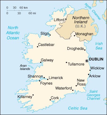
Ireland |

|
Background: A failed 1916 Easter Monday Rebellion touched off several
years of guerrilla warfare that in 1921 resulted in independence from
the UK for the 26 southern counties; the six northern counties (Ulster)
remained part of Great Britain. In 1948 Ireland withdrew from the British
Commonwealth; it joined the European Community in 1973. Irish governments
have sought the peaceful unification of Ireland and have cooperated with
Britain against terrorist groups. A peace settlement for Northern Ireland,
approved in 1998, has not yet been implemented. Location: Western Europe, occupying five-sixths of the island of Ireland in the North Atlantic Ocean, west of Great Britain Area: Total: 70,280 sq km Land: 68,890 sq km Water: 1,390 sq km Land Boundaries: Total: 360 km Border Countries: UK 360 km Coastline: 1,448 km Elevation Extremes: Lowest Point: Atlantic Ocean 0 m Highest Point: Carrauntoohil 1,041 m Population: 3,797,257 (July 2000 est.) Ethnic Groups: Celtic, English Languages: English is the language generally used, Irish (Gaelic) spoken mainly in areas located along the western seaboard Information courtesy of the CIA World Factbook. |
Copyright © 1992-2012 Adam Bartlett.