Destinations:
- Bath
- Belgium
- Bradgate and Groby
- Corfe Castle
- Dorset
- Dorset's Beaches
- The Grand Canyon
- Greece
- Hawaii
- Hawaii's Volcanoes
- The Hoover Dam
- Ibiza
- Ireland
- Kenilworth
- Las Vegas - 1
- Las Vegas - 2
- Montreal
- New York
- Niagara Falls
- Salisbury
- Scotland
- Skellig Islands
- Special Effects and Others
- Stonehenge
- Stratford
- Toronto
- Warwick
- York
890,000 visitors
since March 2001.

Kenilworth
United Kingdom |

|
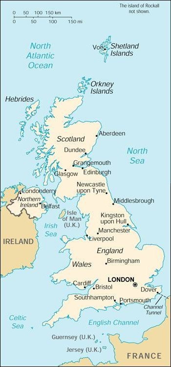
Background: Great Britain, the dominant industrial and maritime power of the
19th century, played a leading role in developing parliamentary democracy and
in advancing literature and science. At its zenith, the British Empire stretched
over one-fourth of the earth's surface. The first half of the 20th century saw the
UK's strength seriously depleted in two World Wars. The second half witnessed the
dismantling of the Empire and the UK rebuilding itself into a modern and prosperous
European nation. The UK currently is weighing the degree of its integration with
continental Europe. A member of the EU, it chose to remain outside of the EMU for
the time being. Constitutional reform is also a significant issue in the UK.
Regional assemblies with varying degrees of power opened in Scotland, Wales,
and Northern Ireland in 1999. Location: Western Europe, islands including the northern one-sixth of the island of Ireland between the North Atlantic Ocean and the North Sea, northwest of France Area: Total: 244,820 sq km Land: 241,590 sq km Water: 3,230 sq km Note: includes Rockall and Shetland Islands Land Boundaries: Total: 360 km Border Countries: Ireland 360 km Coastline: 12,429 km Elevation Extremes: Lowest Point: Fenland -4 m Highest Point: Ben Nevis 1,343 Population: 59,511,464 (July 2000 est.) Ethnic Groups: English 81.5%, Scottish 9.6%, Irish 2.4%, Welsh 1.9%, Ulster 1.8%, West Indian, Indian, Pakistani, and other 2.8% Languages: English, Welsh (about 26% of the population of Wales), Scottish form of Gaelic (about 60,000 in Scotland) Information courtesy of the CIA World Factbook. |
Copyright © 1992-2012 Adam Bartlett.