Destinations:
- Bath
- Belgium
- Bradgate and Groby
- Corfe Castle
- Dorset
- Dorset's Beaches
- The Grand Canyon
- Greece
- Hawaii
- Hawaii's Volcanoes
- The Hoover Dam
- Ibiza
- Ireland
- Kenilworth
- Las Vegas - 1
- Las Vegas - 2
- Montreal
- New York
- Niagara Falls
- Salisbury
- Scotland
- Skellig Islands
- Special Effects and Others
- Stonehenge
- Stratford
- Toronto
- Warwick
- York
890,000 visitors
since March 2001.

Greece
Greece |

|
Background: Greece achieved its independence from the Ottoman Empire
in 1829. During the second half of the 19th century and the first half
of the 20th century, it gradually added neighbouring islands and territories
with Greek-speaking populations. Following the defeat of communist rebels
in 1949, Greece joined NATO in 1952. A military dictatorship, which in 1967
had suspended many political liberties and forced the king to flee the
country, was itself overthrown seven years later. Democratic elections in
1974 abolished the monarchy and created a parliamentary republic; Greece
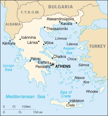
joined the EU in 1981. Location: Southern Europe, bordering the Aegean Sea, Ionian Sea, and the Mediterranean Sea, between Albania and Turkey Area: Total: 131,940 sq km Land: 130,800 sq km Water: 1,140 sq km Land Boundaries: Total: 1,210 km Border Countries: Albania 282 km, Bulgaria 494 km, Turkey 206 km, The Former Yugoslav Republic of Macedonia 228km Coastline: 13,676 km Elevation Extremes: Lowest Point: Mediterranean Sea 0 m Highest Point: Mount Olympus 2,917 m Population: 10,601,527 (July 2000 est.) Ethnic Groups: Greek 98%, other 2% Note: the Greek Government states there are no ethnic divisions in Greece Languages: Greek 99% (official), English, French Information courtesy of the CIA World Factbook. |
Copyright © 1992-2012 Adam Bartlett.