Destinations:
- Bath
- Belgium
- Bradgate and Groby
- Corfe Castle
- Dorset
- Dorset's Beaches
- The Grand Canyon
- Greece
- Hawaii
- Hawaii's Volcanoes
- The Hoover Dam
- Ibiza
- Ireland
- Kenilworth
- Las Vegas - 1
- Las Vegas - 2
- Montreal
- New York
- Niagara Falls
- Salisbury
- Scotland
- Skellig Islands
- Special Effects and Others
- Stonehenge
- Stratford
- Toronto
- Warwick
- York
890,000 visitors
since March 2001.

Belgium
Belgium |
|
Background: Belgium became independent from the
Netherlands in 1830 and was occupied by Germany during World Wars I and II. It has
prospered in the past half century as a modern, technologically advanced European
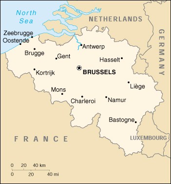
state and member of NATO and the EU. Location: Western Europe, bordering the North Sea, between France and the Netherlands Area: Total: 30,510 sq km Land: 30,230 sq km Water: 280 sq km Land Boundaries: Total: 1,385 km Border Countries: France 620 km, Germany 167 km, Luxembourg 148 km, Netherlands 450 km Coastline: 66 km Elevation Extremes: Lowest Point: North Sea 0 m Highest Point: Signal de Botrange 694 m Population: 10,241,506 (July 2000 est.) Ethnic Groups: Fleming 58%, Walloon 31%, mixed or other 11% Languages: Dutch 58%, French 32%, German 10%, legally bilingual Information courtesy of the CIA World Factbook. |
Copyright © 1992-2012 Adam Bartlett.